“Just a Half-Mornin's Hike 'Tween Humbug Creek and Mother Trucker's Store…”
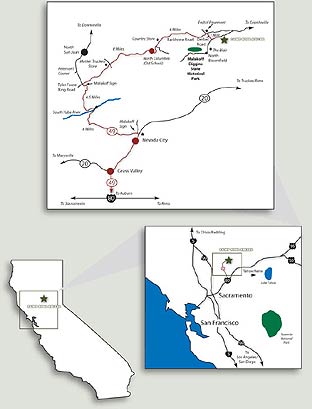
Driving Directions from Sacramento:
- Take I-80 East to Auburn at the Grass Valley exit.
- Follow Highway 49 North, past Grass Valley and Nevada City. (Note: There is no gas available after Nevada City.)
- Just north of Nevada City, take Highway 49 left toward Downieville.
- Remain on Highway 49 as it passes over the South Fork of the Yuba River. From there, it will wind for 4-1/2 miles to the junction at Tyler Foot Crossing Road.
- At this junction, make a right onto Tyler Foot Crossing Road.
- Eight miles ahead, you will pass the old school house at North Columbia. 1-1/2 miles further, Tyler Foot Crossing Road branches left toward Allegheny and the Cruzon Grade Road goes straight toward Graniteville.
- Follow Cruzon Grade Road for 4-1/2 miles to the Malakoff Diggins State Park turnoff at Derbec Road.
- Turn right at this turnoff toward the Camp. The road dead-ends after one mile.
- Turn left and drive .2 mile to Camp Ross Relles, looking for Camp signs along the route.